
Shendurney WLS topographic map
Interactive map
Click on the map to display elevation.
About this map
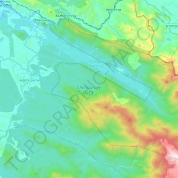
Name: Shendurney WLS topographic map, elevation, terrain.
Location: Shendurney WLS, Thenmala, Punalur, Kollam, Kerala, India (8.80628 77.07888 8.96954 77.28082)
Average elevation: 367 m
Minimum elevation: 42 m
Maximum elevation: 1,639 m
Other topographic maps
Click on a map to view its topography, its elevation and its terrain.