
Asansol Kulti Township topographic map
Interactive map
Click on the map to display elevation.
About this map
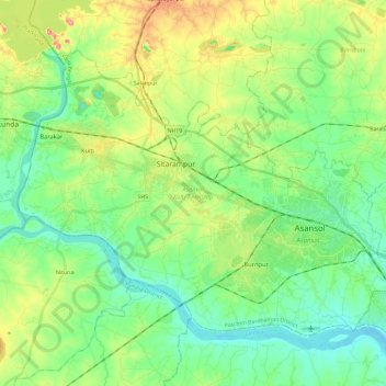
Name: Asansol Kulti Township topographic map, elevation, terrain.
Location: Asansol Kulti Township, Paschim Bardhaman, West Bengal, India (23.62746 86.79886 23.78589 87.03122)
Average elevation: 125 m
Minimum elevation: 79 m
Maximum elevation: 228 m
Other topographic maps
Click on a map to view its topography, its elevation and its terrain.
Asansol
India > West Bengal > Asansol Kulti Township > Asansol
Asansol, Asansol Kulti Township, Purba Bardhaman, West Bengal, 713300, India
Average elevation: 123 m