
Conyers topographic map
Interactive map
Click on the map to display elevation.
About this map
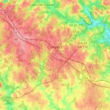
Name: Conyers topographic map, elevation, terrain.
Location: Conyers, Rockdale County, Georgia, United States (33.62497 -84.04573 33.69510 -83.92308)
Average elevation: 251 m
Minimum elevation: 193 m
Maximum elevation: 292 m
Other topographic maps
Click on a map to view its topography, its elevation and its terrain.
Velta
United States > Georgia > Rockdale County
Velta, Rockdale County, Georgia, 30094, United States
Average elevation: 235 m
Hi Roc Shores
United States > Georgia > Rockdale County
Hi Roc Shores, Rockdale County, Georgia, 30012, United States
Average elevation: 242 m