
Núi Thành District topographic map
Interactive map
Click on the map to display elevation.
About this map
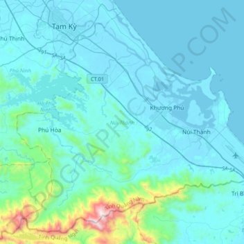
Name: Núi Thành District topographic map, elevation, terrain.
Location: Núi Thành District, Quang Nam Province, 0065, Vietnam (15.30744 108.42207 15.58427 108.73912)
Average elevation: 129 m
Minimum elevation: -3 m
Maximum elevation: 1,354 m
Other topographic maps
Click on a map to view its topography, its elevation and its terrain.
Duy Phước
Vietnam > Quang Nam Province > Duy Xuyên District
Duy Phước, Duy Xuyên District, Quảng Nam Province, 51506, Vietnam
Average elevation: 5 m
Duy Xuyên District
Duy Xuyên District, Quang Nam Province, Vietnam
Average elevation: 112 m
Sông Tam Kỳ
Vietnam > Quang Nam Province > Núi Thành District > Tam Kỳ City
Sông Tam Kỳ, Tam Kỳ City, Núi Thành District, Quang Nam Province, Vietnam
Average elevation: 13 m
Hoi An
Vietnam > Quang Nam Province > Hoi An
Hoi An, Hội An, Quang Nam Province, 0510, Vietnam
Average elevation: 25 m
Bà nà hills
Vietnam > Quang Nam Province > Đông Giang District
Bà nà hills, Đông Giang District, Quang Nam Province, Vietnam
Average elevation: 915 m
ffff
Vietnam > Quang Nam Province > Nam Trà My District
ffff, Nam Trà My District, Quang Nam Province, Vietnam
Average elevation: 463 m
sông Bàn Thạch
Vietnam > Quang Nam Province > Tam Kỳ City
sông Bàn Thạch, Tam Kỳ City, Quang Nam Province, Vietnam
Average elevation: 5 m
ffff
ffff, Nam Trà My District, Quang Nam Province, Vietnam
Average elevation: 454 m
Hiệp Đức District
Hiệp Đức District, Quang Nam Province, Vietnam
Average elevation: 221 m