
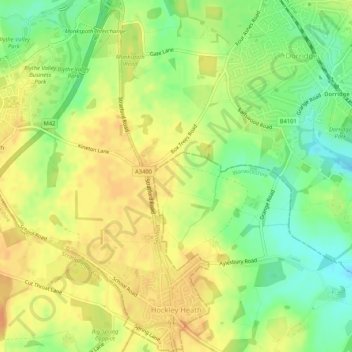
Hockley Heath topographic map
Interactive map
Click on the map to display elevation.
About this map
Name: Hockley Heath topographic map, elevation, terrain.
Average elevation: 134 m
Minimum elevation: 113 m
Maximum elevation: 148 m
By the 18th century the manor had passed to the Archers of Umberslade Hall and the hamlet was briefly reoriented around its Umberslade area. The Umberslade estate sits on the border of Nuthurst and Tanworth in Arden and had been built for the Archer family in 1680. Lord Archer raised a 70 feet (21 m) limestone block obelisk on the estate in 1749. The reason for this is unclear, possibly to celebrate his elevation to the peerage or just, as was the fashion during that period, as a folly. However, according to local folklore it is said to mark the passing of a favoured horse, which is buried beneath it.
Other topographic maps
Click on a map to view its topography, its elevation and its terrain.
Waring's Green
United Kingdom > England > Metropolitan Borough of Solihull > Cheswick Green > Illshaw Heath
Waring's Green, Illshaw Heath, Cheswick Green, Metropolitan Borough of Solihull, West Midlands Combined Authority, England, B94 6BP, United Kingdom
Average elevation: 139 m
Temple Balsall
United Kingdom > England > Metropolitan Borough of Solihull
Temple Balsall, Balsall, Metropolitan Borough of Solihull, West Midlands Combined Authority, England, B93 0AN, United Kingdom
Average elevation: 109 m
Little Clowes Wood
United Kingdom > England > Metropolitan Borough of Solihull > Tidbury Green
Little Clowes Wood, Wood Lane, Tidbury Green, Metropolitan Borough of Solihull, West Midlands Combined Authority, England, B94 5JL, United Kingdom
Average elevation: 150 m
Four Oaks
United Kingdom > England > Metropolitan Borough of Solihull
Four Oaks, Metropolitan Borough of Solihull, West Midlands Combined Authority, England, CV7 7SL, United Kingdom
Average elevation: 121 m
Coleshill Heath
United Kingdom > England > Metropolitan Borough of Solihull
Coleshill Heath, Metropolitan Borough of Solihull, West Midlands Combined Authority, England, B37 7PD, United Kingdom
Average elevation: 96 m
Knowle
United Kingdom > England > Metropolitan Borough of Solihull
Knowle, Metropolitan Borough of Solihull, West Midlands Combined Authority, England, B93 9NR, United Kingdom
Average elevation: 119 m
Barston
United Kingdom > England > Metropolitan Borough of Solihull
Barston, Metropolitan Borough of Solihull, West Midlands Combined Authority, England, United Kingdom
Average elevation: 104 m
Elmdon Heath
United Kingdom > England > Metropolitan Borough of Solihull
Elmdon Heath, Metropolitan Borough of Solihull, West Midlands Combined Authority, England, B91 2SA, United Kingdom
Average elevation: 120 m
Balsall Common
United Kingdom > England > Metropolitan Borough of Solihull
Balsall Common, Metropolitan Borough of Solihull, West Midlands Combined Authority, England, CV7 7DP, United Kingdom
Average elevation: 117 m
Monkspath
United Kingdom > England > Metropolitan Borough of Solihull
Monkspath, Metropolitan Borough of Solihull, West Midlands Combined Authority, England, B90 4SZ, United Kingdom
Average elevation: 133 m
Blossomfield
United Kingdom > England > Metropolitan Borough of Solihull
Blossomfield, Metropolitan Borough of Solihull, West Midlands Combined Authority, England, B91 1TP, United Kingdom
Average elevation: 137 m
Haslucks Green
United Kingdom > England > Metropolitan Borough of Solihull
Haslucks Green, Metropolitan Borough of Solihull, West Midlands Combined Authority, England, B90 1BF, United Kingdom
Average elevation: 143 m
Tidbury Green
United Kingdom > England > Metropolitan Borough of Solihull
Tidbury Green, Metropolitan Borough of Solihull, West Midlands Combined Authority, England, United Kingdom
Average elevation: 149 m