
San Nicolas topographic map
Interactive map
Click on the map to display elevation.
About this map
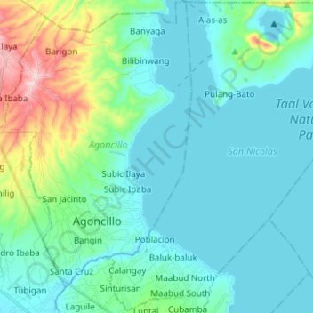
Name: San Nicolas topographic map, elevation, terrain.
Location: San Nicolas, Batangas, Calabarzon, 4207, Philippines (13.90002 120.93230 14.01875 121.02002)
Average elevation: 68 m
Minimum elevation: -2 m
Maximum elevation: 384 m
Other topographic maps
Click on a map to view its topography, its elevation and its terrain.
Volcano Island
Philippines > Batangas > San Nicolas
Volcano Island, San Nicolas, Batangas, Calabarzon, 4207, Philippines
Average elevation: 33 m
Taal Volcano
Philippines > Batangas > San Nicolas
Taal Volcano, San Nicolas, Batangas, Calabarzon, 4207, Philippines
Average elevation: 91 m