
Make a donation
Gear up for your next adventure:
As an Amazon Associate, this site earns from qualifying purchases at no extra cost to you.
Lo de Marcos topographic map
Click on the map to display elevation.
Make a donation
Gear up for your next adventure:
As an Amazon Associate, this site earns from qualifying purchases at no extra cost to you.
About this map
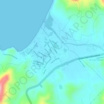
Name: Lo de Marcos topographic map, elevation, terrain.
Location: Lo de Marcos, Bahía de Banderas, Nayarit, Mexico (20.95376 -105.35255 20.95386 -105.35245)
Average elevation: 24 m
Minimum elevation: -1 m
Maximum elevation: 152 m
Make a donation
Gear up for your next adventure:
As an Amazon Associate, this site earns from qualifying purchases at no extra cost to you.
Other topographic maps
Click on a map to view its topography, its elevation and its terrain.
Ruiz
The area of the municipality extends from the western lowlands to the foothills of the Sierra Madre Occidental. About 70% of its surface is made up of rugged lands. The municipal seat is located on the coastal plain at an elevation of 30 meters above sea level. It is here where the agricultural lands are…
Average elevation: 623 m