
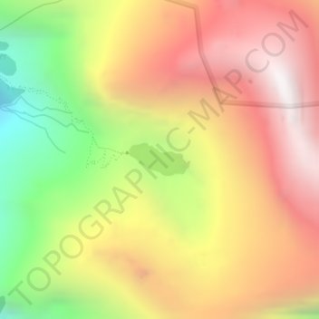
Hemkund topographic map
Interactive map
Click on the map to display elevation.
About this map
Name: Hemkund topographic map, elevation, terrain.
Average elevation: 4,367 m
Minimum elevation: 3,475 m
Maximum elevation: 5,094 m
Other topographic maps
Click on a map to view its topography, its elevation and its terrain.
Valley of Flowers National Park
India > Uttarakhand > Joshimath Tehsil
Valley of Flowers National Park, Joshimath Tehsil, Chamoli District, Uttarakhand, India
Average elevation: 4,606 m
Dadon
India > Uttarakhand > Joshimath Tehsil > Joshimath
Dadon, Joshimath, Joshimath Tehsil, Chamoli district, Uttarakhand, India
Average elevation: 2,107 m
Pangarchulla
India > Uttarakhand > Joshimath Tehsil
Pangarchulla, Joshimath Tehsil, Chamoli District, Uttarakhand, 246483, India
Average elevation: 4,061 m
Joshimath
India > Uttarakhand > Joshimath Tehsil
Joshimath, Joshimath Tehsil, Chamoli district, Uttarakhand, India
Average elevation: 2,272 m
Nanda Devi
India > Uttarakhand > Joshimath Tehsil
Nanda Devi, Joshimath Tehsil, Chamoli District, Uttarakhand, India
Average elevation: 6,567 m
Pinola
India > Uttarakhand > Joshimath Tehsil > Govindghat > Pinola
Pinola, Govindghat, Joshimath Tehsil, Chamoli district, Uttarakhand, India
Average elevation: 2,454 m
Badrinath
India > Uttarakhand > Joshimath Tehsil
Badrinath, Joshimath Tehsil, Chamoli District, Uttarakhand, India
Average elevation: 4,052 m