
Darjeeling topographic map
Interactive map
Click on the map to display elevation.
About this map
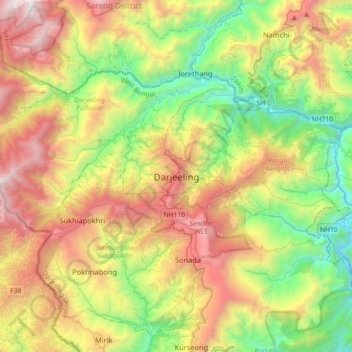
Name: Darjeeling topographic map, elevation, terrain.
Average elevation: 1,324 m
Minimum elevation: 162 m
Maximum elevation: 3,065 m
Other topographic maps
Click on a map to view its topography, its elevation and its terrain.
Sandakphu
India > West Bengal > Darjeeling Pulbazar
Sandakphu, Darjeeling Pulbazar, Darjeeling, West Bengal, India
Average elevation: 3,285 m