
Wyre Piddle topographic map
Interactive map
Click on the map to display elevation.
About this map
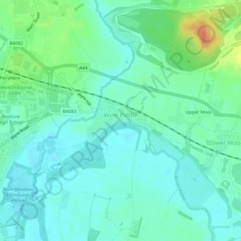
Name: Wyre Piddle topographic map, elevation, terrain.
Location: Wyre Piddle, Wychavon, Worcestershire, England, United Kingdom (52.11626 -2.06842 52.13428 -2.03649)
Average elevation: 25 m
Minimum elevation: 13 m
Maximum elevation: 57 m
Worcestershire trails, hiking, mountain biking, running and outdoor activities
Other topographic maps
Click on a map to view its topography, its elevation and its terrain.
Badsey Lane Nature Reserve
United Kingdom > England > Worcestershire > Wychavon > Evesham
Average elevation: 37 m
Atch Lench
United Kingdom > England > Worcestershire > Wychavon > Church Lench
Average elevation: 80 m