
Deerfield topographic map
Interactive map
Click on the map to display elevation.
About this map
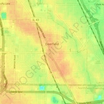
Name: Deerfield topographic map, elevation, terrain.
Location: Deerfield, Lake County, Illinois, 60015, United States (42.14582 -87.88398 42.18918 -87.82107)
Average elevation: 204 m
Minimum elevation: 180 m
Maximum elevation: 216 m
Other topographic maps
Click on a map to view its topography, its elevation and its terrain.
Lake Naomi
United States > Illinois > Lake County > Hawthorn Woods > White Birch Lakes
Average elevation: 261 m
Bishops Ridge
United States > Illinois > Lake County > Kildeer > Bishops Ridge
Average elevation: 253 m