
Turnu Măgurele topographic map
Interactive map
Click on the map to display elevation.
About this map
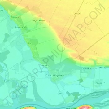
Name: Turnu Măgurele topographic map, elevation, terrain.
Location: Turnu Măgurele, Teleorman, 145200, Romania (43.70658 24.77673 43.85278 24.96278)
Average elevation: 59 m
Minimum elevation: 11 m
Maximum elevation: 188 m
A ferry plies across the Danube to the Bulgarian city of Nikopol. There are some vestiges of a Roman bridge across the Danube, built in 330 by Constantine the Great. It is built in the Danube plain in a fertile land called Burnas plain. At 4 km (2.5 mi) south-west from it the river Olt joins the Danube. Its medium altitude is 31 m (102 ft) above sea level.
Other topographic maps
Click on a map to view its topography, its elevation and its terrain.
Alexandria
Romania > Teleorman > Alexandria
Alexandria, Teleorman, 140017, Romania
Average elevation: 79 m