Geolocate

Sunnemo topographic map

Interactive map

Click on the map to display elevation.

About this map

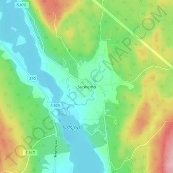
Name: Sunnemo topographic map, elevation, terrain.

Location: Sunnemo, Hagfors kommun, Värmland County, 683 95, Sweden (59.86428 13.70226 59.90428 13.74226)

Average elevation: 181 m

Minimum elevation: 121 m

Maximum elevation: 305 m

Other topographic maps

Click on a map to view its topography, its elevation and its terrain.

Kils kommun

Sweden > Värmland County

Average elevation: 104 m

Pottern

Sweden > Värmland County

Average elevation: 145 m

Säffle kommun

Sweden > Värmland County

Average elevation: 89 m

Karlstads kommun

Sweden > Värmland County

Average elevation: 109 m

Filipstads kommun

Sweden > Värmland County

Average elevation: 241 m

Storfors kommun

Sweden > Värmland County

Average elevation: 158 m

Sunne kommun

Sweden > Värmland County

Average elevation: 194 m

Torsby kommun

Sweden > Värmland County

Average elevation: 356 m

Hagfors kommun

Sweden > Värmland County

Average elevation: 256 m

Arvika kommun

Sweden > Värmland County

Average elevation: 182 m