
Montgomery Street Park topographic map
Interactive map
Click on the map to display elevation.
About this map
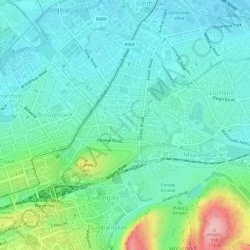
Name: Montgomery Street Park topographic map, elevation, terrain.
Average elevation: 43 m
Minimum elevation: 4 m
Maximum elevation: 176 m
Scotland trails, hiking, mountain biking, running and outdoor activities
Other topographic maps
Click on a map to view its topography, its elevation and its terrain.
Currie
United Kingdom > Scotland > City of Edinburgh
The period 1921-1951 brought great changes with the building of more council houses in Currie and private building along Lanark Road. Wider scale development began in the late 1950s and early 1960s with the construction of a private housing estate to the east of Curriehill Road. House builders began to promote…
Average elevation: 163 m
Hermitage of Braid and Blackford Hill Local Nature Reserve
United Kingdom > Scotland > City of Edinburgh
Average elevation: 107 m