
Thank you for supporting this site ❤️
Make a donation
Make a donation
Gear up for your next adventure:
As an Amazon Associate, this site earns from qualifying purchases at no extra cost to you.
Karangazi topographic map
Click on the map to display elevation.
Thank you for supporting this site ❤️
Make a donation
Make a donation
Gear up for your next adventure:
As an Amazon Associate, this site earns from qualifying purchases at no extra cost to you.
About this map
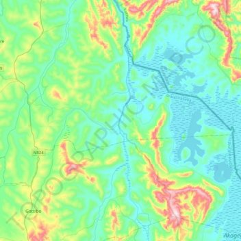
Name: Karangazi topographic map, elevation, terrain.
Location: Karangazi, Nyagatare District, Eastern Province, Rwanda (-1.54663 30.32875 -1.32239 30.74093)
Average elevation: 1,393 m
Minimum elevation: 1,276 m
Maximum elevation: 1,823 m
Thank you for supporting this site ❤️
Make a donation
Make a donation
Gear up for your next adventure:
As an Amazon Associate, this site earns from qualifying purchases at no extra cost to you.