Erlangen topographic map
Interactive map
Click on the map to display elevation.
About this map
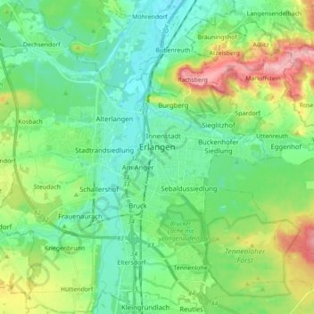
Name: Erlangen topographic map, elevation, terrain.
Location: Erlangen, Bavaria, Germany (49.53271 10.91536 49.64558 11.05360)
Average elevation: 302 m
Minimum elevation: 264 m
Maximum elevation: 395 m
In 1435 the church, which had been the daughter church of St. Martin in Forchheim up until this point, was elevated to its own parish. The main task of the Erlangen priest was the pastoral care in the city of Erlangen and the St. Martin's Chapel on the Martinsbühl, which was now named for the first time. Furthermore, the document of elevation determines the pastoral care of the surrounding villages of Bubenreuth, Bräuningshof, Marloffstein, Spardorf and Sieglitzhof, whose inhabitants visited the chapel of the Virgin Mary, were pastorally cared for from this chapel and were provided with the sacraments. This addition confirms that there was at least one vicar at the Frauenkirche (Church of Our Lady) before it was elevated to a parish church. The ecclesiastical life was accordingly pronounced and varied at the time. In addition to the parish priest, there were two vicars for the early and middle mass. Whether the financially very badly equipped Mass Beneficiaries were always occupied is not known. With the introduction of the Reformation by Margrave George the Pious in 1528 in Erlangen, the Catholic life of the church was extinguished completely for many years. Only few things from this time remain today: five figures of saints from the former Marienkirche, which today are placed on the northern altar wall in the Altstädter Trinity Church, a measuring cup and the equestrian statue of Saint Martin, which is exhibited annually on St. Martin's Day in the Martinsbühler church.
Other topographic maps
Click on a map to view its topography, its elevation and its terrain.
Burgau
Germany > Bavaria > Landkreis Günzburg
Burgau, Landkreis Günzburg, Bavaria, 89331, Germany
Average elevation: 474 m
Langenberg
Germany > Bavaria > Landkreis Kitzingen
Langenberg, Geiselwind, Landkreis Kitzingen, Bavaria, 96160, Germany
Average elevation: 399 m
Schwöb
Germany > Bavaria > Landkreis Berchtesgadener Land
Schwöb, Schönau am Königssee, Landkreis Berchtesgadener Land, Bavaria, 83471, Germany
Average elevation: 770 m
Ries
Germany > Bavaria > Landkreis Donau-Ries
Ries, Landkreis Donau-Ries, Bavaria, Germany
Average elevation: 484 m
Schönberg
Germany > Bavaria > Landkreis Traunstein > Kienberg
Schönberg, Kienberg, Obing (VGem), Landkreis Traunstein, Bavaria, 83361, Germany
Average elevation: 538 m
Trainmeusel
Germany > Bavaria > Landkreis Forchheim > Wiesenttal
Trainmeusel, Wiesenttal, Landkreis Forchheim, Bavaria, 91346, Germany
Average elevation: 433 m
Eglfing
Germany > Bavaria > Landkreis München > Haar
Eglfing, Haar, Landkreis München, Bavaria, 85540, Germany
Average elevation: 540 m
Schmelzmühle
Germany > Bavaria > Landkreis Amberg-Sulzbach > Freihung
Schmelzmühle, Freihung, Landkreis Amberg-Sulzbach, Bavaria, 92271, Germany
Average elevation: 427 m
Hohenfels
Germany > Bavaria > Landkreis Neumarkt in der Oberpfalz
Hohenfels, Landkreis Neumarkt in der Oberpfalz, Bavaria, 92366, Germany
Average elevation: 467 m
Eichstätt
Germany > Bavaria > Landkreis Eichstätt
Eichstätt, Landkreis Eichstätt, Bavaria, 85072, Germany
Average elevation: 490 m
Olching
Germany > Bavaria > Landkreis Fürstenfeldbruck
Olching, Landkreis Fürstenfeldbruck, Bavaria, 82140, Germany
Average elevation: 509 m
82140
Germany > Bavaria > Landkreis Fürstenfeldbruck > Olching
82140, Olching, Landkreis Fürstenfeldbruck, Bavaria, Germany
Average elevation: 504 m
Brunnen
Germany > Bavaria > Landkreis Neuburg-Schrobenhausen
Brunnen, Schrobenhausen, Landkreis Neuburg-Schrobenhausen, Bavaria, 86564, Germany
Average elevation: 399 m
Kolbermoor
Germany > Bavaria > Landkreis Rosenheim
Kolbermoor, Landkreis Rosenheim, Bavaria, 83059, Germany
Average elevation: 467 m
Wind
Germany > Bavaria > Landkreis Bamberg
Wind, Pommersfelden, Landkreis Bamberg, Bavaria, 96178, Germany
Average elevation: 284 m
Oberdaching
Germany > Bavaria > Landkreis Dingolfing-Landau > Pilsting
Oberdaching, Pilsting, Landkreis Dingolfing-Landau, Bavaria, Germany
Average elevation: 399 m
Tauting
Germany > Bavaria > Landkreis Weilheim-Schongau
Tauting, Eglfing, Huglfing (VGem), Landkreis Weilheim-Schongau, Bavaria, Germany
Average elevation: 650 m
Deggendorf
Germany > Bavaria > Landkreis Deggendorf
Deggendorf, Landkreis Deggendorf, Bavaria, 94469, Germany
Average elevation: 449 m
Mitteleschenbach
Germany > Bavaria > Ansbach (district)
Mitteleschenbach, Wolframs-Eschenbach (VGem), Ansbach (district), Bavaria, 91734, Germany
Average elevation: 439 m
Gattendorf
Germany > Bavaria > Landkreis Hof
Gattendorf, Verwaltungsgemeinschaft Feilitzsch, Landkreis Hof, Bavaria, 95185, Germany
Average elevation: 547 m
Tutzing
Germany > Bavaria > Landkreis Starnberg
Tutzing, Landkreis Starnberg, Bavaria, 82327, Germany
Average elevation: 632 m
Bierhütte
Germany > Bavaria > Landkreis Freyung-Grafenau
Bierhütte, Hohenau, Landkreis Freyung-Grafenau, Bavaria, 94545, Germany
Average elevation: 716 m
Kulmbach
Germany > Bavaria > Landkreis Kulmbach
Kulmbach, Landkreis Kulmbach, Bavaria, 95326, Germany
Average elevation: 395 m
Selb
Germany > Bavaria > Landkreis Wunsiedel im Fichtelgebirge
Selb, Landkreis Wunsiedel im Fichtelgebirge, Bavaria, 95100, Germany
Average elevation: 589 m
Walking
Germany > Bavaria > Landkreis Rottal-Inn > Wittibreut
Walking, Wittibreut, Landkreis Rottal-Inn, Bavaria, 84384, Germany
Average elevation: 504 m
Hobbach
Germany > Bavaria > Landkreis Miltenberg > Eschau
Hobbach, Eschau, Landkreis Miltenberg, Bavaria, Germany
Average elevation: 303 m
Rain
Germany > Bavaria > Landkreis Rosenheim > Kiefersfelden
Rain, Kiefersfelden, Landkreis Rosenheim, Bavaria, 83088, Germany
Average elevation: 538 m
Ramsau
Germany > Bavaria > Landkreis Rosenheim > Nußdorf am Inn
Ramsau, Nußdorf am Inn, Landkreis Rosenheim, Bavaria, 83131, Germany
Average elevation: 602 m
Pfarrkirchen
Germany > Bavaria > Landkreis Rottal-Inn
Pfarrkirchen, Landkreis Rottal-Inn, Bavaria, 84347, Germany
Average elevation: 429 m
Muth
Germany > Bavaria > Landkreis Passau > Loizersdorf
Muth, Loizersdorf, Tittling, Tittling (VGem), Landkreis Passau, Bavaria, 94104, Germany
Average elevation: 474 m
Marktheidenfeld
Germany > Bavaria > Landkreis Main-Spessart
Marktheidenfeld, Landkreis Main-Spessart, Bavaria, 97828, Germany
Average elevation: 260 m
Bergstein
Germany > Bavaria > Landkreis Amberg-Sulzbach > Illschwang
Bergstein, Illschwang, Illschwang (VGem), Landkreis Amberg-Sulzbach, Bavaria, 92278, Germany
Average elevation: 548 m
Pittenhart
Germany > Bavaria > Landkreis Traunstein
Pittenhart, Obing (VGem), Landkreis Traunstein, Bavaria, 83132, Germany
Average elevation: 567 m
Weitnau
Germany > Bavaria > Landkreis Oberallgäu
Weitnau, Weitnau (VGem), Landkreis Oberallgäu, Bavaria, 87480, Germany
Average elevation: 887 m
Obersalzberg
Germany > Bavaria > Landkreis Berchtesgadener Land > Berchtesgaden > Untersalzberg I
Obersalzberg, Untersalzberg I, Berchtesgaden, Landkreis Berchtesgadener Land, Bavaria, 83471, Germany
Average elevation: 933 m
Neuhausen
Germany > Bavaria > Landkreis Deggendorf
Neuhausen, Offenberg, Landkreis Deggendorf, Bavaria, 94560, Germany
Average elevation: 341 m
Putting
Germany > Bavaria > Landkreis Rottal-Inn > Wurmannsquick
Putting, Wurmannsquick, Landkreis Rottal-Inn, Bavaria, 84329, Germany
Average elevation: 464 m
Gungolding
Germany > Bavaria > Landkreis Eichstätt
Gungolding, Walting, Eichstätt (VGem), Landkreis Eichstätt, Bavaria, 85137, Germany
Average elevation: 441 m
Fichtelberg
Germany > Bavaria > Landkreis Bayreuth
Fichtelberg, Landkreis Bayreuth, Bavaria, 95686, Germany
Average elevation: 697 m
Eisenhofen
Germany > Bavaria > Landkreis Dachau
Eisenhofen, Erdweg, Landkreis Dachau, Bavaria, 85253, Germany
Average elevation: 493 m
Kienberg
Germany > Bavaria > Landkreis Traunstein
Kienberg, Obing (VGem), Landkreis Traunstein, Bavaria, 83361, Germany
Average elevation: 549 m
Grainau
Germany > Bavaria > Landkreis Garmisch-Partenkirchen
Grainau, Landkreis Garmisch-Partenkirchen, Bavaria, 82491, Germany
Average elevation: 1,399 m
Heisting
Germany > Bavaria > Landkreis Altötting > Pleiskirchen
Heisting, Pleiskirchen, Landkreis Altötting, Bavaria, 84568, Germany
Average elevation: 426 m
Waldkirchen
Germany > Bavaria > Landkreis Freyung-Grafenau
Waldkirchen, Landkreis Freyung-Grafenau, Bavaria, 94065, Germany
Average elevation: 599 m
Emskirchen
Germany > Bavaria > Landkreis Neustadt an der Aisch-Bad Windsheim
Emskirchen, Landkreis Neustadt an der Aisch-Bad Windsheim, Bavaria, 91448, Germany
Average elevation: 367 m
Hutthurm
Germany > Bavaria > Landkreis Passau
Hutthurm, Landkreis Passau, Bavaria, 94116, Germany
Average elevation: 432 m
Elmau
Germany > Bavaria > Landkreis Garmisch-Partenkirchen
Elmau, Krün, Landkreis Garmisch-Partenkirchen, Bavaria, 82493, Germany
Average elevation: 1,130 m