Geolocate

Cwm topographic map

Interactive map

Click on the map to display elevation.

About this map

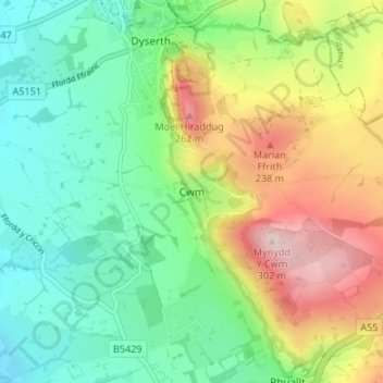
Name: Cwm topographic map, elevation, terrain.

Location: Cwm, Denbighshire, Wales, LL18 5SL, United Kingdom (53.26470 -3.42587 53.30470 -3.38587)

Average elevation: 111 m

Minimum elevation: 7 m

Maximum elevation: 297 m

Denbighshire trails, hiking, mountain biking, running and outdoor activities

Other topographic maps

Click on a map to view its topography, its elevation and its terrain.

Brenig Reservoir

United Kingdom > Wales > Denbighshire

Average elevation: 410 m

Nantglyn

United Kingdom > Wales > Denbighshire

Average elevation: 352 m

Gwyddelwern

United Kingdom > Wales > Denbighshire

Average elevation: 249 m

Betws Gwerfil Goch

United Kingdom > Wales > Denbighshire

Average elevation: 297 m

Llangynhafal

United Kingdom > Wales > Denbighshire

Average elevation: 160 m

Parc Pendre

United Kingdom > Wales > Denbighshire > Prestatyn

Average elevation: 53 m

Gronant Dunes

United Kingdom > Wales > Denbighshire > Prestatyn

Average elevation: 11 m

Llanelidan

United Kingdom > Wales > Denbighshire

Average elevation: 221 m

Tremeirchion

United Kingdom > Wales > Denbighshire

Average elevation: 123 m

Betws Gwerfil Goch

United Kingdom > Wales > Denbighshire

Average elevation: 297 m