
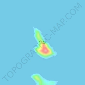
Outer Brass Island topographic map
Interactive map
Click on the map to display elevation.
About this map
Name: Outer Brass Island topographic map, elevation, terrain.
Average elevation: 3 m
Minimum elevation: 0 m
Maximum elevation: 112 m
Other topographic maps
Click on a map to view its topography, its elevation and its terrain.
Saint Thomas
United States > United States Virgin Islands > Saint Thomas - Saint John District > Charlotte Amalie
Average elevation: 15 m
Saint Croix
United States > United States Virgin Islands > Saint Croix District > Christiansted
Average elevation: 11 m
Saint Croix
United States > United States Virgin Islands > Saint Croix District > Christiansted
Average elevation: 11 m
Saint Croix
United States > United States Virgin Islands > Saint Croix District > Christiansted
Average elevation: 11 m
Frederiksted
United States > United States Virgin Islands > Saint Croix District
Rainforests occur on the western side of St. Croix due to the topography featuring 1,400 foot or 400 metres peaks, which gather moisture from the trade winds. This rainforest climate is unique to the Frederiksted side of St. Croix.
Average elevation: 14 m
Cruz Bay
United States > United States Virgin Islands > Saint Thomas - Saint John District
Average elevation: 24 m
Saint John
United States > United States Virgin Islands > Saint Thomas - Saint John District > East End
Average elevation: 26 m
Saint Croix
United States > United States Virgin Islands > Saint Croix District > Christiansted
Average elevation: 11 m
Little Princess South
United States > United States Virgin Islands > Saint Croix District
Average elevation: 51 m
Charlotte Amalie West
United States > United States Virgin Islands > Saint Thomas - Saint John District
Average elevation: 52 m
Contentment
United States > United States Virgin Islands > Saint Croix District
Average elevation: 58 m
Saint Thomas
United States > United States Virgin Islands > Saint Thomas - Saint John District > Charlotte Amalie
Average elevation: 15 m
Saint Thomas
United States > United States Virgin Islands > Saint Thomas - Saint John District > Charlotte Amalie
Average elevation: 15 m
Charlotte Amalie West
United States > United States Virgin Islands > Saint Thomas - Saint John District
Average elevation: 40 m
Charlotte Amalie
United States > United States Virgin Islands > Saint Thomas - Saint John District > Charlotte Amalie
Average elevation: 60 m
Christiansted
United States > United States Virgin Islands > Saint Croix District
Average elevation: 45 m
Saint Croix
United States > United States Virgin Islands > Saint Croix District > Christiansted
Average elevation: 11 m
Central
United States > United States Virgin Islands > Saint Thomas - Saint John District
Average elevation: 174 m
Saint Thomas
United States > United States Virgin Islands > Saint Thomas - Saint John District > Charlotte Amalie
Average elevation: 15 m
Saint Thomas - Saint John District
United States > United States Virgin Islands
Average elevation: 6 m
Saint Thomas
United States > United States Virgin Islands > Saint Thomas - Saint John District > Charlotte Amalie
Average elevation: 15 m
Saint Croix
United States > United States Virgin Islands > Saint Croix District > Christiansted
Average elevation: 11 m
Fortuna
United States > United States Virgin Islands > Saint Thomas - Saint John District
Average elevation: 40 m
Charlotte Amalie
United States > United States Virgin Islands > Saint Thomas - Saint John District > Charlotte Amalie
Average elevation: 68 m
Saint Thomas
United States > United States Virgin Islands > Saint Thomas - Saint John District > Charlotte Amalie
Average elevation: 15 m
Morningstar
United States > United States Virgin Islands > Saint Croix District > Morningstar
Average elevation: 68 m
Saint Croix District
United States > United States Virgin Islands > Saint Croix District
Average elevation: 6 m
Saint John
United States > United States Virgin Islands > Saint Thomas - Saint John District > East End
Average elevation: 26 m
Anna's Retreat
United States > United States Virgin Islands > Saint Thomas - Saint John District
Average elevation: 99 m
Saint Thomas - Saint John District
United States > United States Virgin Islands
Average elevation: 6 m
Buck Island Reef National Monument
United States > United States Virgin Islands
Average elevation: 4 m
Virgin Islands
United States > United States Virgin Islands > Saint Croix District
Average elevation: 2 m
Charlotte Amalie
United States > United States Virgin Islands > Saint Thomas - Saint John District > Charlotte Amalie
Average elevation: 62 m