
Titusville topographic map
Interactive map
Click on the map to display elevation.
About this map
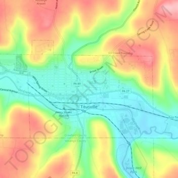
Name: Titusville topographic map, elevation, terrain.
Location: Titusville, Crawford County, Pennsylvania, United States (41.61719 -79.69919 41.63989 -79.64406)
Average elevation: 419 m
Minimum elevation: 350 m
Maximum elevation: 500 m
The City of Titusville is located in the southeastern Corner of Crawford County in the Pittsburgh High Plateau. The city is drained by Oil Creek, a south-flowing tributary of the Allegheny River, and two tributaries to Oil Creek, Pine Creek, and Church Run. The lowest elevation in the City of Titusville is 1,150 ft (350 m) where Oil Creek flows south of out of the city. The highest elevation is 1,650 ft (500 m) on a high point at the northeastern corner of the city.
Other topographic maps
Click on a map to view its topography, its elevation and its terrain.
Sugar Lake
United States > Pennsylvania > Crawford County
Sugar Lake, Wayne Township, Crawford County, Pennsylvania, United States
Average elevation: 428 m
Cochranton
United States > Pennsylvania > Crawford County > Cochranton
Cochranton, Crawford County, Pennsylvania, United States
Average elevation: 351 m
Spartansburg
United States > Pennsylvania > Crawford County > Spartansburg
Spartansburg, Crawford County, Pennsylvania, United States
Average elevation: 463 m
Rome Township
United States > Pennsylvania > Crawford County
Rome Township, Crawford County, Pennsylvania, United States
Average elevation: 472 m