
Zaqatala District topographic map
Interactive map
Click on the map to display elevation.
About this map
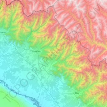
Name: Zaqatala District topographic map, elevation, terrain.
Location: Zaqatala District, Sheki-Zaqatala, Azerbaijan (41.37337 46.29742 41.86255 47.02268)
Average elevation: 1,413 m
Minimum elevation: 165 m
Maximum elevation: 3,814 m
Other topographic maps
Click on a map to view its topography, its elevation and its terrain.
Ilisu
Azerbaijan > Sheki-Zaqatala > Qax İngiloy
Ilisu, Qax İngiloy, Qakh District, Sheki-Zaqatala, 3417, Azerbaijan
Average elevation: 1,492 m
Sheki
Azerbaijan > Sheki-Zaqatala > Sheki
Sheki, Shaki, Sheki-Zaqatala, Azerbaijan
Average elevation: 702 m