Geolocate

Timboroa topographic map

Click on the map to display elevation.

About this map

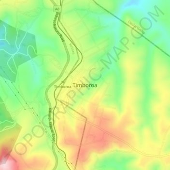
Name: Timboroa topographic map, elevation, terrain.

Location: Timboroa, Eldama Ravine, Baringo, Rift Valley, Kenya (0.02296 35.50671 0.10296 35.58671)

Average elevation: 2,697 m

Minimum elevation: 2,487 m

Maximum elevation: 2,889 m

Other topographic maps

Click on a map to view its topography, its elevation and its terrain.

Eldama Ravine

Kenya > Baringo > Eldama Ravine > Eldama Ravine

Average elevation: 2,175 m

Gear up for your next adventure:

📕Outdoor Navigation Books - Learn traditional and modern navigation techniques
🐕Dog Hiking Gear - Equipment for hiking safely with dogs
🥤Collapsible Water Bottles - Save space in your rucksack as you consume your water
❄️Walking Crampons - Added traction for icy slopes and winter peak bagging
🧥Waterproof Hiking Jackets - Rain protection for walking in all weather conditions

As an Amazon Associate, this site earns from qualifying purchases at no extra cost to you.