
Desroches Island topographic map
Interactive map
Click on the map to display elevation.
About this map
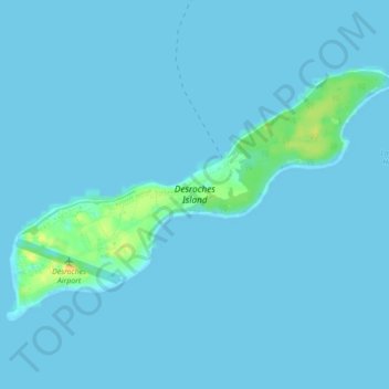
Name: Desroches Island topographic map, elevation, terrain.
Location: Desroches Island, Seychelles (-5.70337 53.64883 -5.67493 53.69290)
Average elevation: 2 m
Minimum elevation: -1 m
Maximum elevation: 27 m
Other topographic maps
Click on a map to view its topography, its elevation and its terrain.
Praslin
Seychelles > Praslin group > Baie Saint Anne District > Baie Sainte Anne
Praslin, Baie Sainte Anne, Baie Saint Anne District, Praslin group, Seychelles
Average elevation: 25 m
Romainville Island
Romainville Island, Victoria, Seychelles
Average elevation: 2 m
Anse Nord D'Est
Anse Nord D'Est, North Coast Road, Ma Constance, Mahé, SEZ, Seychelles
Average elevation: 41 m