
Eno River topographic map
Interactive map
Click on the map to display elevation.
About this map
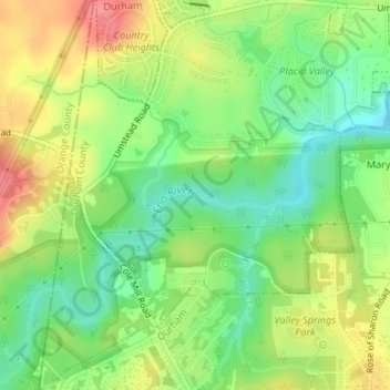
Name: Eno River topographic map, elevation, terrain.
Average elevation: 134 m
Minimum elevation: 100 m
Maximum elevation: 176 m
Other topographic maps
Click on a map to view its topography, its elevation and its terrain.
Durham
United States > North Carolina > Durham County
Durham is located in the east-central part of the Piedmont region at 35°59′19″N 78°54′26″W / 35.98861°N 78.90722°W / 35.98861; -78.90722 (35.988644, −78.907167). Like much of the region, its topography is generally flat with some rolling hills.
Average elevation: 117 m