
Cripple Creek topographic map
Interactive map
Click on the map to display elevation.
About this map
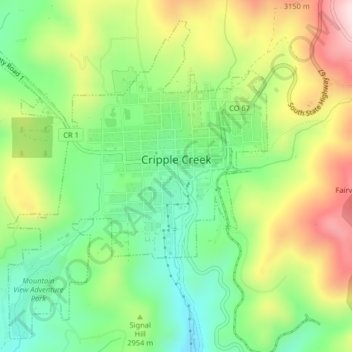
Name: Cripple Creek topographic map, elevation, terrain.
Location: Cripple Creek, Teller County, Colorado, United States (38.73050 -105.20831 38.75981 -105.16776)
Average elevation: 2,946 m
Minimum elevation: 2,796 m
Maximum elevation: 3,165 m
For many years, Cripple Creek's high valley, at an elevation of 9,494 feet (2,894 m), was considered no more important than a cattle pasture. Many prospectors avoided the area after the Mount Pisgah hoax, a mini gold rush caused by salting (adding gold to worthless rock).
Other topographic maps
Click on a map to view its topography, its elevation and its terrain.
Florissant Fossil Beds National Monument
United States > Colorado > Teller County
Florissant Fossil Beds National Monument, County Road 121, Teller County, Colorado, 80816, United States
Average elevation: 2,616 m
Florissant
United States > Colorado > Teller County
Florissant, Teller County, Colorado, United States
Average elevation: 2,556 m
Divide
United States > Colorado > Teller County
Divide, Teller County, Colorado, United States
Average elevation: 2,796 m
Woodland Park
United States > Colorado > Teller County
Woodland Park, Teller County, Colorado, 80863, United States
Average elevation: 2,652 m