
Enskede postort topographic map
Interactive map
Click on the map to display elevation.
About this map
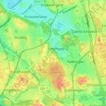
Name: Enskede postort topographic map, elevation, terrain.
Average elevation: 36 m
Minimum elevation: 16 m
Maximum elevation: 57 m
Other topographic maps
Click on a map to view its topography, its elevation and its terrain.
Gamla stan
Sweden > Stockholm County > Stockholm
Gamla stan, Södermalms stadsdelsområde, Stockholm, Stockholm County, Region Svealand, Sweden
Average elevation: 19 m
Södermalm
Sweden > Stockholm County > Stockholm
Södermalm, Stockholm, Stockholm County, Region Svealand, Sweden
Average elevation: 22 m
Hägersten
Sweden > Stockholm County > Stockholm
Hägersten, Hägersten-Liljeholmens stadsdelsområde, Stockholm, Stockholms kommun, Stockholm County, Region Svealand, Sweden
Average elevation: 28 m
Högdalstoppen
Sweden > Stockholm County > Stockholm
Högdalstoppen, Stockholm, Stockholms kommun, Stockholm County, Region Svealand, 124 57, Sweden
Average elevation: 40 m