
Make a donation
Gear up for your next adventure:
As an Amazon Associate, this site earns from qualifying purchases at no extra cost to you.
Westport topographic map
Click on the map to display elevation.
Make a donation
Gear up for your next adventure:
As an Amazon Associate, this site earns from qualifying purchases at no extra cost to you.
About this map
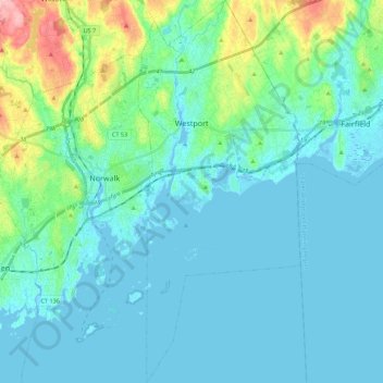
Name: Westport topographic map, elevation, terrain.
Average elevation: 22 m
Minimum elevation: -7 m
Maximum elevation: 137 m
Make a donation
Gear up for your next adventure:
As an Amazon Associate, this site earns from qualifying purchases at no extra cost to you.
Other topographic maps
Click on a map to view its topography, its elevation and its terrain.
Thomas Mountain
United States > Connecticut > Western Connecticut Planning Region > Danbury
Average elevation: 197 m
Palestine
United States > Connecticut > Western Connecticut Planning Region > Newtown
Average elevation: 184 m
Northfield
United States > Connecticut > Western Connecticut Planning Region > Stamford
Average elevation: 25 m
Five Points
United States > Connecticut > Western Connecticut Planning Region > Redding Ridge
Average elevation: 185 m
Make a donation
Gear up for your next adventure:
As an Amazon Associate, this site earns from qualifying purchases at no extra cost to you.
Daniels Mill
United States > Connecticut > Western Connecticut Planning Region > New Canaan
Average elevation: 100 m
Five Points
United States > Connecticut > Western Connecticut Planning Region > Redding Ridge
Average elevation: 185 m
North Mianus
United States > Connecticut > Western Connecticut Planning Region > Greenwich
Average elevation: 32 m
Chimney Point
United States > Connecticut > Western Connecticut Planning Region > New Milford
Average elevation: 142 m
Make a donation
Gear up for your next adventure:
As an Amazon Associate, this site earns from qualifying purchases at no extra cost to you.
Saugatuck
United States > Connecticut > Western Connecticut Planning Region > Westport
Average elevation: 15 m
Mill River Park
United States > Connecticut > Western Connecticut Planning Region > Stamford
Average elevation: 18 m
Wildmans Landing
United States > Connecticut > Western Connecticut Planning Region > Danbury
Average elevation: 156 m
Bold Rock
United States > Connecticut > Western Connecticut Planning Region > Darien
Average elevation: 58 m
Make a donation
Gear up for your next adventure:
As an Amazon Associate, this site earns from qualifying purchases at no extra cost to you.
Godfrey Corner
United States > Connecticut > Western Connecticut Planning Region > Weston
Average elevation: 110 m
King Street
United States > Connecticut > Western Connecticut Planning Region > Danbury
Average elevation: 237 m
South End
United States > Connecticut > Western Connecticut Planning Region > Stamford
Average elevation: 11 m
Long Ridge
United States > Connecticut > Western Connecticut Planning Region > Stamford
Average elevation: 126 m
Make a donation
Gear up for your next adventure:
As an Amazon Associate, this site earns from qualifying purchases at no extra cost to you.
Wataba Lake
United States > Connecticut > Western Connecticut Planning Region > Ridgefield
Average elevation: 205 m
Byram
United States > Connecticut > Western Connecticut Planning Region > Greenwich
Average elevation: 19 m
West Norwalk
United States > Connecticut > Western Connecticut Planning Region > Norwalk
Average elevation: 50 m
Deer Hill
United States > Connecticut > Western Connecticut Planning Region > Danbury
Average elevation: 135 m
Make a donation
Gear up for your next adventure:
As an Amazon Associate, this site earns from qualifying purchases at no extra cost to you.
Godfrey Corner
United States > Connecticut > Western Connecticut Planning Region > Weston
Average elevation: 110 m
Town Open Space (Ashford Lane)
United States > Connecticut > Western Connecticut Planning Region > Newtown
Average elevation: 200 m
Winnipauk
United States > Connecticut > Western Connecticut Planning Region > Norwalk
Average elevation: 51 m
Roxbury
United States > Connecticut > Western Connecticut Planning Region > Stamford
Average elevation: 48 m
Make a donation
Gear up for your next adventure:
As an Amazon Associate, this site earns from qualifying purchases at no extra cost to you.
Tokeneke
United States > Connecticut > Western Connecticut Planning Region > Darien
Average elevation: 14 m
Glenville
United States > Connecticut > Western Connecticut Planning Region > Greenwich
Average elevation: 54 m
North Stamford
United States > Connecticut > Western Connecticut Planning Region > Stamford
Average elevation: 89 m
Palmers Hill
United States > Connecticut > Western Connecticut Planning Region > Stamford
Average elevation: 31 m
Make a donation
Gear up for your next adventure:
As an Amazon Associate, this site earns from qualifying purchases at no extra cost to you.
Belltown
United States > Connecticut > Western Connecticut Planning Region > Stamford
Average elevation: 32 m
Mianus
United States > Connecticut > Western Connecticut Planning Region > Greenwich
Average elevation: 23 m
Mianus
United States > Connecticut > Western Connecticut Planning Region > Greenwich
Average elevation: 23 m
Old Greenwich
United States > Connecticut > Western Connecticut Planning Region > Greenwich
Average elevation: 12 m
Make a donation
Gear up for your next adventure:
As an Amazon Associate, this site earns from qualifying purchases at no extra cost to you.
Candlewood Lake Club
United States > Connecticut > Western Connecticut Planning Region > New Milford
Average elevation: 143 m
Taylor Corners
United States > Connecticut > Western Connecticut Planning Region > New Fairfield
Average elevation: 226 m
Taylor Corners
United States > Connecticut > Western Connecticut Planning Region > New Fairfield
Average elevation: 226 m
Contentment Island
United States > Connecticut > Western Connecticut Planning Region > Darien
Average elevation: 63 m
Make a donation
Gear up for your next adventure:
As an Amazon Associate, this site earns from qualifying purchases at no extra cost to you.
Beckettville
United States > Connecticut > Western Connecticut Planning Region > Danbury
Average elevation: 155 m
Riverbank
United States > Connecticut > Western Connecticut Planning Region > Stamford
Average elevation: 72 m
Honey Hill
United States > Connecticut > Western Connecticut Planning Region > Wilton
Average elevation: 126 m
Turn of River
United States > Connecticut > Western Connecticut Planning Region > Stamford
Average elevation: 58 m
Make a donation
Gear up for your next adventure:
As an Amazon Associate, this site earns from qualifying purchases at no extra cost to you.
Riverside
United States > Connecticut > Western Connecticut Planning Region > Greenwich > Old Greenwich
Average elevation: 13 m
Pinneys Corners
United States > Connecticut > Western Connecticut Planning Region > New Canaan
Average elevation: 143 m
Riverside
United States > Connecticut > Western Connecticut Planning Region > Greenwich > Old Greenwich
Average elevation: 13 m
Candlewood Springs
United States > Connecticut > Western Connecticut Planning Region > New Milford
Average elevation: 146 m
Make a donation
Gear up for your next adventure:
As an Amazon Associate, this site earns from qualifying purchases at no extra cost to you.
Sandy Hook
United States > Connecticut > Western Connecticut Planning Region > Newtown
Average elevation: 113 m
Beaver Brook
United States > Connecticut > Western Connecticut Planning Region > Danbury
Average elevation: 119 m
Candlewood Orchards
United States > Connecticut > Western Connecticut Planning Region > Brookfield
Average elevation: 141 m