
Murray Bridge topographic map
Interactive map
Click on the map to display elevation.
About this map
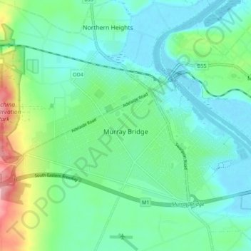
Name: Murray Bridge topographic map, elevation, terrain.
Average elevation: 34 m
Minimum elevation: -1 m
Maximum elevation: 142 m
Other topographic maps
Click on a map to view its topography, its elevation and its terrain.
Rockleigh
Australia > South Australia > The Rural City of Murray Bridge
Rockleigh, The Rural City of Murray Bridge, South Australia, 5254, Australia
Average elevation: 214 m
Toora
Australia > South Australia > The Rural City of Murray Bridge
Toora, The Rural City of Murray Bridge, South Australia, 5253, Australia
Average elevation: 25 m