
Flims topographic map
Interactive map
Click on the map to display elevation.
About this map
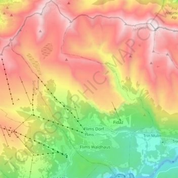
Name: Flims topographic map, elevation, terrain.
Location: Flims, Imboden, Grisons, Switzerland (46.80620 9.21303 46.91627 9.34150)
Average elevation: 1,898 m
Minimum elevation: 604 m
Maximum elevation: 3,199 m
Other topographic maps
Click on a map to view its topography, its elevation and its terrain.
Tamins
Switzerland > Grisons > Imboden
Tamins, Imboden, Grisons, 7015, Switzerland
Average elevation: 1,549 m
Ringelspitz
Switzerland > Grisons > Imboden > Trin
Ringelspitz, Trin, Imboden, Grisons, Switzerland
Average elevation: 2,628 m
Hinterrhein
Switzerland > Grisons > Imboden > Domat/Ems
Hinterrhein, Domat/Ems, Imboden, Grisons, 7013, Switzerland
Average elevation: 839 m