
Wilmore topographic map
Interactive map
Click on the map to display elevation.
About this map
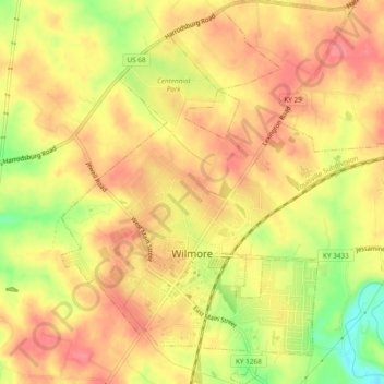
Name: Wilmore topographic map, elevation, terrain.
Location: Wilmore, Jessamine County, Kentucky, 40390, United States (37.85131 -84.67643 37.88869 -84.63626)
Average elevation: 272 m
Minimum elevation: 223 m
Maximum elevation: 297 m
Other topographic maps
Click on a map to view its topography, its elevation and its terrain.
Nicholasville
United States > Kentucky > Jessamine County
Nicholasville, Jessamine County, Kentucky, 40356, United States
Average elevation: 285 m
Pollard
United States > Kentucky > Jessamine County
Pollard, Jessamine County, Kentucky, United States
Average elevation: 259 m