
Kwun Tong District topographic map
Interactive map
Click on the map to display elevation.
About this map
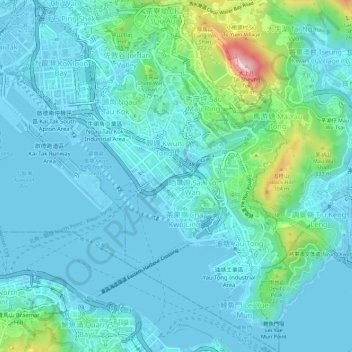
Name: Kwun Tong District topographic map, elevation, terrain.
Location: Kwun Tong District, Kowloon, Hong Kong, China (22.28228 114.20171 22.33496 114.24558)
Average elevation: 61 m
Minimum elevation: -23 m
Maximum elevation: 399 m
Other topographic maps
Click on a map to view its topography, its elevation and its terrain.
Kowloon Walled City Park
Kowloon Walled City Park, Kau Pui Shek, Kowloon City, Kowloon City District, Kowloon, Hong Kong, China
Average elevation: 28 m
Jordan Valley
Jordan Valley, Shun On Road, Choi Wan, Jordan Valley, Kowloon, Kwun Tong District, Hong Kong, China
Average elevation: 107 m
Kowloon City District
Kowloon City District, Kowloon, Hong Kong, China
Average elevation: 37 m