
Sti Fadma topographic map
Interactive map
Click on the map to display elevation.
About this map
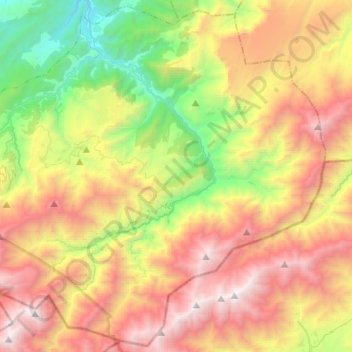
Name: Sti Fadma topographic map, elevation, terrain.
Average elevation: 2,275 m
Minimum elevation: 926 m
Maximum elevation: 3,891 m
Other topographic maps
Click on a map to view its topography, its elevation and its terrain.
Oued Ourika ⵓⵔⵉⴽⴰ نهر أوريكا
Oued Ourika ⵓⵔⵉⴽⴰ نهر أوريكا, Sti Fadma, caïdat de Sti Fadma, Cercle de Tahannaout دائرة تحناوت, Al Haouz Province, Marrakech-Safi, Morocco
Average elevation: 2,227 m