
Biescas topographic map
Interactive map
Click on the map to display elevation.
About this map
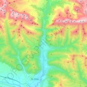
Name: Biescas topographic map, elevation, terrain.
Location: Biescas, Alto Gállego, Huesca, Aragon, Spain (42.52936 -0.43230 42.72723 -0.21201)
Average elevation: 1,472 m
Minimum elevation: 775 m
Maximum elevation: 2,826 m
The town of Biescas is located at 875 meters altitude on the banks of the Gállego river. The municipality extends along a small plain and includes the canyon to access to the Tena Valley. At 72 km north of the main city Huesca, Biescas is a communication hub between the regions of Jacetania and Sobrarbe. The town is strategically located to crossing the Gállego river, as a link between the valleys of Tena and Ara.
Other topographic maps
Click on a map to view its topography, its elevation and its terrain.
Piedrafita de Jaca
Spain > Aragon > Alto Gállego
Piedrafita de Jaca, Biescas, Alto Gállego, Huesca, Aragon, 22665, Spain
Average elevation: 1,321 m
Peña Telera
Spain > Aragon > Alto Gállego > Biescas
Peña Telera, Biescas, Alto Gállego, Huesca, Aragon, 22665, Spain
Average elevation: 2,130 m
Sallent de Gállego
Spain > Aragon > Alto Gállego > Sallent de Gállego
Sallent de Gállego, Alto Gállego, Huesca, Aragon, Spain
Average elevation: 1,975 m