
Chef-Boutonne topographic map
Interactive map
Click on the map to display elevation.
About this map
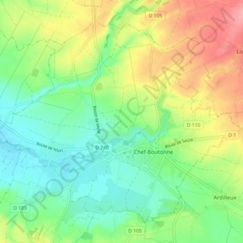
Name: Chef-Boutonne topographic map, elevation, terrain.
Average elevation: 108 m
Minimum elevation: 71 m
Maximum elevation: 165 m
Other topographic maps
Click on a map to view its topography, its elevation and its terrain.
Tillou
France > New Aquitaine > Chef-Boutonne
Tillou, Chef-Boutonne, Niort, Deux-Sèvres, New Aquitaine, Metropolitan France, 79110, France
Average elevation: 107 m