
Lure topographic map
Interactive map
Click on the map to display elevation.
About this map
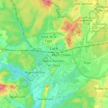
Name: Lure topographic map, elevation, terrain.
Average elevation: 304 m
Minimum elevation: 278 m
Maximum elevation: 357 m
Other topographic maps
Click on a map to view its topography, its elevation and its terrain.
Saint-Valère
France > Bourgogne – Franche-Comté > Haute-Saône > Port-sur-Saône
Average elevation: 245 m
Le Tertre
France > Bourgogne – Franche-Comté > Haute-Saône > Amont-et-Effreney
Average elevation: 504 m
L'Enclose
France > Bourgogne – Franche-Comté > Haute-Saône > Servance-Miellin
Average elevation: 566 m
La Vieille Voie
France > Bourgogne – Franche-Comté > Haute-Saône > Corravillers
Average elevation: 593 m