
Lakeview topographic map
Interactive map
Click on the map to display elevation.
About this map
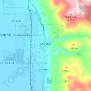
Name: Lakeview topographic map, elevation, terrain.
Location: Lakeview, Lake County, Oregon, 97630, United States (42.16423 -120.37558 42.21158 -120.33630)
Average elevation: 1,562 m
Minimum elevation: 1,440 m
Maximum elevation: 1,960 m
Other topographic maps
Click on a map to view its topography, its elevation and its terrain.
Summer Lake
United States > Oregon > Lake County
Summer Lake, Lake County, Oregon, 97640, United States
Average elevation: 1,406 m
Sawed Horn
United States > Oregon > Lake County
Sawed Horn, Lake County, Oregon, United States
Average elevation: 1,323 m
Plush
United States > Oregon > Lake County
Plush, Lake County, Oregon, 97637, United States
Average elevation: 1,407 m