
Ahlatlıbel Mahallesi topographic map
Interactive map
Click on the map to display elevation.
About this map
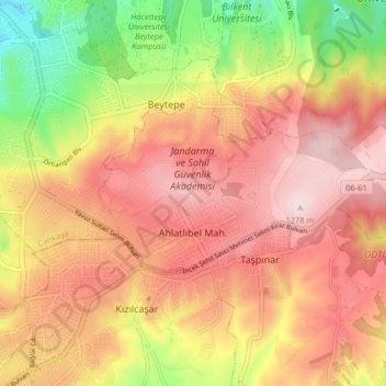
Name: Ahlatlıbel Mahallesi topographic map, elevation, terrain.
Average elevation: 1,144 m
Minimum elevation: 951 m
Maximum elevation: 1,277 m
Other topographic maps
Click on a map to view its topography, its elevation and its terrain.
Seğmenler Parkı
Turkey > Central Anatolia Region > Ankara
Seğmenler Parkı, Çankaya Mahallesi, Ankara, Çankaya, Ankara, Central Anatolia Region, Turkey
Average elevation: 1,001 m