
Finsteraarhorn topographic map
Interactive map
Click on the map to display elevation.
About this map
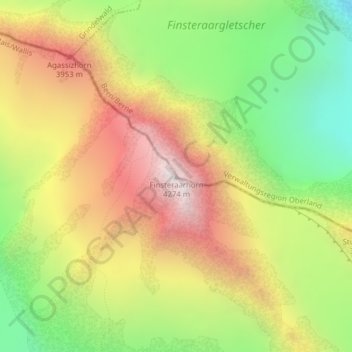
Name: Finsteraarhorn topographic map, elevation, terrain.
Location: Finsteraarhorn, Fieschertal, Goms, Wallis, Switzerland (46.53730 8.12606 46.53740 8.12616)
Average elevation: 3,420 m
Minimum elevation: 2,676 m
Maximum elevation: 4,205 m
Other topographic maps
Click on a map to view its topography, its elevation and its terrain.
Fieschergletscher
Switzerland > Wallis > Goms > Fieschertal
Fieschergletscher, Fieschertal, Goms, Oberland administrative region, Wallis, Switzerland
Average elevation: 3,042 m
Aletsch Glacier
Switzerland > Wallis > Goms > Fieschertal
Aletsch Glacier, Fieschertal, Goms, Wallis, Switzerland
Average elevation: 2,532 m
Moench
Switzerland > Wallis > Goms > Fieschertal
Moench, Fieschertal, Goms, Oberland administrative region, Wallis, 3801, Switzerland
Average elevation: 3,392 m