
Morbach topographic map
Interactive map
Click on the map to display elevation.
About this map
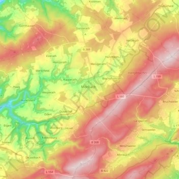
Name: Morbach topographic map, elevation, terrain.
Average elevation: 529 m
Minimum elevation: 255 m
Maximum elevation: 769 m
The municipality lies at an elevation of between 430 and 770 m above sea level in the low mountain range of the Hunsrück on the boundary with the Birkenfeld district, roughly 25 km southeast of Wittlich and 35 km east of Trier. Its population is 11,051. The nearest town is Bernkastel-Kues.
Other topographic maps
Click on a map to view its topography, its elevation and its terrain.
Rapperath
Germany > Rhineland-Palatinate > Landkreis Bernkastel-Wittlich > Morbach
Rapperath, Morbach, Landkreis Bernkastel-Wittlich, Rhineland-Palatinate, Germany
Average elevation: 454 m