
Chino topographic map
Interactive map
Click on the map to display elevation.
About this map
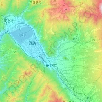
Name: Chino topographic map, elevation, terrain.
Location: Chino, Nagano Prefecture, Chubu Region, Japan (35.91660 138.11191 36.11245 138.37452)
Average elevation: 1,140 m
Minimum elevation: 752 m
Maximum elevation: 2,246 m
Chino is located in a mountainous area of the east-central Nagano prefecture. Notable mountains within the city limits include Mount Yatsugatake, Mount Tateshina, and Mount Kirigamine. Chino city hall is located at an elevation of 801 meters and is thus the highest city hall location in Japan.
Other topographic maps
Click on a map to view its topography, its elevation and its terrain.
Mount Fuji
Japan > Sunto County > Oyama
Mount Fuji, Oyama, Sunto County, Shizuoka Prefecture, Chubu Region, Japan
Average elevation: 3,261 m
Lake Sanaru
Lake Sanaru, Hamamatsu, Shizuoka Prefecture, Chubu Region, Japan
Average elevation: 16 m
Motoyama
Motoyama, Nagaoka County, Kochi Prefecture, 781-3601, Japan
Average elevation: 679 m
Setouchi
Setouchi, Oshima County, Kagoshima Prefecture, Japan
Average elevation: 26 m
Higashishirakawa
Higashishirakawa, Kamo County, Gifu Prefecture, Chubu Region, 509-1392, Japan
Average elevation: 658 m
Nishikigaoka-chuo Park
Nishikigaoka-chuo Park, Nishikigaoka 2-chome, Aoba Ward, Sendai, Miyagi Prefecture, Japan
Average elevation: 197 m
Katsura Imperial Villa
Katsura Imperial Villa, Road No. 142, Katsura-Kasugacho, Nishikyo Ward, Kyoto, Kyoto Prefecture, 615-8013, Japan
Average elevation: 25 m