
Buttermere topographic map
Interactive map
Click on the map to display elevation.
About this map
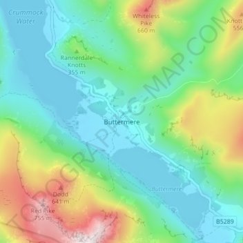
Name: Buttermere topographic map, elevation, terrain.
Average elevation: 297 m
Minimum elevation: 99 m
Maximum elevation: 804 m
Other topographic maps
Click on a map to view its topography, its elevation and its terrain.
Peel Place
United Kingdom > England > Allerdale > Buttermere
Peel Place, Buttermere, Allerdale, Cumbria, North West England, England, CA13 9UY, United Kingdom
Average elevation: 280 m