
Indiana topographic map
Interactive map
Click on the map to display elevation.
About this map
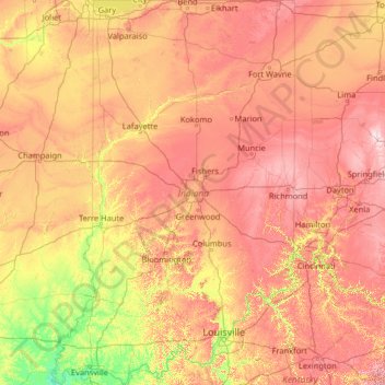
Name: Indiana topographic map, elevation, terrain.
Location: Indiana, United States (37.77174 -88.09970 41.76137 -84.78461)
Average elevation: 226 m
Minimum elevation: 103 m
Maximum elevation: 458 m
The average altitude of Indiana is about 760 feet (230 m) above sea level. The highest point in the state is Hoosier Hill in Wayne County at 1,257 feet (383 m) above sea level. The lowest point at 320 feet (98 m) above sea level is in Posey County, where the Wabash River meets the Ohio River. The resulting elevation span, 937 feet (286 m), is the narrowest of any non-coastal U.S. state. Only 2,850 square miles (7,400 km2) have an altitude greater than 1,000 feet (300 m) and this area is enclosed within 14 counties. About 4,700 square miles (12,000 km2) have an elevation of less than 500 feet (150 m), mostly concentrated along the Ohio and lower Wabash Valleys, from Tell City and Terre Haute to Evansville and Mount Vernon.
Other topographic maps
Click on a map to view its topography, its elevation and its terrain.
Madison
United States > Wisconsin > Dane County
Madison, Dane County, Wisconsin, United States
Average elevation: 284 m
Jacksonville
United States > Florida > Duval County
Jacksonville, Duval County, Florida, United States
Average elevation: 10 m
Brooklyn
United States > New York > New York
Brooklyn, Kings County, New York, United States
Average elevation: 9 m
Staten Island
United States > New York > New York
Staten Island, Richmond County, New York, United States
Average elevation: 9 m
Lancaster County
Lancaster County, Pennsylvania, United States
Average elevation: 158 m
Allegheny County
Allegheny County, Pennsylvania, United States
Average elevation: 325 m
Boulder
United States > Colorado > Boulder County
Boulder, Boulder County, Colorado, United States
Average elevation: 1,785 m
Seattle
United States > Washington > King County
Seattle, King County, Washington, United States
Average elevation: 40 m
Miami-Dade County
Miami-Dade County, Florida, United States
Average elevation: 3 m
Spokane
United States > Washington > Spokane County
Spokane, Spokane County, Washington, United States
Average elevation: 655 m
Rudyard
United States > Michigan > Chippewa County
Rudyard, Rudyard Township, Chippewa County, Michigan, United States
Average elevation: 209 m
Sarasota
United States > Florida > Sarasota County
Sarasota, Sarasota County, Florida, United States
Average elevation: 7 m
Santa Fe
United States > New Mexico > Santa Fe County
Santa Fe, Santa Fe County, New Mexico, United States
Average elevation: 2,221 m
Albuquerque
United States > New Mexico > Bernalillo County
Albuquerque, Bernalillo County, New Mexico, United States
Average elevation: 1,688 m
Honolulu
United States > Hawaii > Honolulu County
Honolulu, Honolulu County, Hawaii, United States
Average elevation: 90 m