
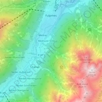
Marktgemeinde Fulpmes topographic map
Interactive map
Click on the map to display elevation.
About this map
Name: Marktgemeinde Fulpmes topographic map, elevation, terrain.
Average elevation: 1,451 m
Minimum elevation: 875 m
Maximum elevation: 2,685 m
The municipality of Fulpmes belongs to the Innsbruck Land district. It has an area of 16.77 square kilometres (6.47 sq mi), and an altitude of 936 metres (3,070 ft). The neighboring municipalities are Neustift to the west and Telfes and Mieders to the east. Fulpmes is the terminal station of the narrow-gauge railway Stubaitalbahn from Innsbruck.
Other topographic maps
Click on a map to view its topography, its elevation and its terrain.
Leutasch
Austria > Tyrol > Bezirk Innsbruck-Land
Leutasch, Bezirk Innsbruck-Land, Tyrol, 6105, Austria
Average elevation: 1,461 m
Gries am Brenner
Austria > Tyrol > Bezirk Innsbruck-Land
Gries am Brenner, Bezirk Innsbruck-Land, Tyrol, 6156, Austria
Average elevation: 1,747 m
Gemeinde Sistrans
Austria > Tyrol > Bezirk Innsbruck-Land
Gemeinde Sistrans, Bezirk Innsbruck-Land, Tyrol, 6073, Austria
Average elevation: 1,224 m
Gemeinde Gnadenwald
Austria > Tyrol > Bezirk Innsbruck-Land
Gemeinde Gnadenwald, Bezirk Innsbruck-Land, Tyrol, 6069, Austria
Average elevation: 1,277 m
Mösern
Austria > Tyrol > Bezirk Innsbruck-Land > Marktgemeinde Telfs
Mösern, Marktgemeinde Telfs, Bezirk Innsbruck-Land, Tyrol, 6408, Austria
Average elevation: 1,100 m
Gemeinde Axams
Austria > Tyrol > Bezirk Innsbruck-Land
Gemeinde Axams, Bezirk Innsbruck-Land, Tyrol, 6094, Austria
Average elevation: 1,449 m
Gemeinde Wattenberg
Austria > Tyrol > Bezirk Innsbruck-Land
Gemeinde Wattenberg, Bezirk Innsbruck-Land, Tyrol, 6113, Austria
Average elevation: 1,813 m
Marktgemeinde Telfs
Austria > Tyrol > Bezirk Innsbruck-Land
Marktgemeinde Telfs, Bezirk Innsbruck-Land, Tyrol, 6410, Austria
Average elevation: 1,162 m
Gurgl
Austria > Tyrol > Bezirk Innsbruck-Land > Gemeinde Leutasch
Gurgl, Gemeinde Leutasch, Bezirk Innsbruck-Land, Tyrol, 6105, Austria
Average elevation: 1,604 m
Glättebach
Austria > Tyrol > Bezirk Innsbruck-Land > Gemeinde Gschnitz
Glättebach, Gemeinde Gschnitz, Bezirk Innsbruck-Land, Tyrol, 6150, Austria
Average elevation: 2,019 m
Axamer Lizum
Austria > Tyrol > Bezirk Innsbruck-Land > Gemeinde Axams > Axamer Lizum
Axamer Lizum, Gemeinde Axams, Bezirk Innsbruck-Land, Tyrol, 6092, Austria
Average elevation: 1,858 m
Gemeinde Navis
Austria > Tyrol > Bezirk Innsbruck-Land > Gemeinde Navis
Gemeinde Navis, Bezirk Innsbruck-Land, Tyrol, 6145, Austria
Average elevation: 1,898 m
Gemeinde Seefeld in Tirol
Austria > Tyrol > Bezirk Innsbruck-Land
Gemeinde Seefeld in Tirol, Bezirk Innsbruck-Land, Tyrol, 6100, Austria
Average elevation: 1,303 m