
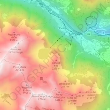
Prato (Leventina) topographic map
Interactive map
Click on the map to display elevation.
About this map
Name: Prato (Leventina) topographic map, elevation, terrain.
Average elevation: 1,755 m
Minimum elevation: 801 m
Maximum elevation: 2,688 m
The municipality is located in the Leventina district, in a depression in the mountains at an elevation of 1,046 m (3,432 ft) near the Monte Piottino gorge. It consists of the village of Prato and the hamlets of Fiesso, Mascengo, Rodi and Morasco.
Other topographic maps
Click on a map to view its topography, its elevation and its terrain.
Sobrio
Switzerland > Ticino > Distretto di Leventina > Sobrio
Sobrio, Faido, Circolo di Giornico, Distretto di Leventina, Ticino, 6749, Switzerland
Average elevation: 1,112 m
Ambrì
Switzerland > Ticino > Distretto di Leventina
Ambrì, Quinto, Circolo di Quinto, Distretto di Leventina, Ticino, 6775, Switzerland
Average elevation: 1,459 m