
Gourock topographic map
Interactive map
Click on the map to display elevation.
About this map
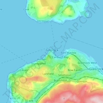
Name: Gourock topographic map, elevation, terrain.
Location: Gourock, Inverclyde, Scotland, PA19 1QU, United Kingdom (55.92200 -4.85787 56.00200 -4.77787)
Average elevation: 49 m
Minimum elevation: 0 m
Maximum elevation: 280 m
Other topographic maps
Click on a map to view its topography, its elevation and its terrain.
Inverkip
United Kingdom > Scotland > Inverclyde
Inverkip, Inverclyde, Scotland, PA16 0BP, United Kingdom
Average elevation: 66 m
Greenock
United Kingdom > Scotland > Inverclyde
Greenock, Inverclyde, Scotland, PA15 1LT, United Kingdom
Average elevation: 80 m
Port Glasgow
United Kingdom > Scotland > Inverclyde
Port Glasgow, Inverclyde, Scotland, PA14 5JH, United Kingdom
Average elevation: 83 m
Kilmacolm
United Kingdom > Scotland > Inverclyde
Kilmacolm, Inverclyde, Scotland, PA13 4HA, United Kingdom
Average elevation: 114 m
Greenock Sugar Sheds
United Kingdom > Scotland > Inverclyde > Greenock
Greenock Sugar Sheds, Bridgend, Greenock, Inverclyde, Scotland, United Kingdom
Average elevation: 35 m