
Mé topographic map
Interactive map
Click on the map to display elevation.
About this map
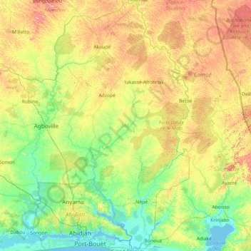
Name: Mé topographic map, elevation, terrain.
Location: Mé, Lagunes, +225, Côte d'Ivoire (5.21528 -4.16385 6.64954 -3.31735)
Average elevation: 95 m
Minimum elevation: -3 m
Maximum elevation: 342 m
Other topographic maps
Click on a map to view its topography, its elevation and its terrain.
Attinguié
Attinguié, Agnéby-Tiassa, Lagunes, Côte d'Ivoire
Average elevation: 111 m
Abreby
Côte d'Ivoire > Lagunes > Abreby
Abreby, Grands-Ponts, Lagunes, Côte d'Ivoire
Average elevation: 4 m