
Deutschlandsberg topographic map
Interactive map
Click on the map to display elevation.
About this map
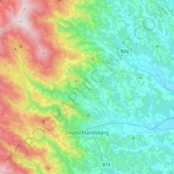
Name: Deutschlandsberg topographic map, elevation, terrain.
Location: Deutschlandsberg, Bezirk Deutschlandsberg, Styria, Austria (46.79310 15.00792 46.92792 15.26645)
Average elevation: 614 m
Minimum elevation: 298 m
Maximum elevation: 1,458 m
Other topographic maps
Click on a map to view its topography, its elevation and its terrain.
Wies
Austria > Styria > Bezirk Deutschlandsberg
Wies, Bezirk Deutschlandsberg, Styria, 8551, Austria
Average elevation: 498 m
Weinebene
Austria > Styria > Bezirk Deutschlandsberg > Bad Schwanberg
Weinebene, Bad Schwanberg, Bezirk Deutschlandsberg, Styria, 8541, Austria
Average elevation: 1,632 m
Stainz
Austria > Styria > Bezirk Deutschlandsberg
Stainz, Bezirk Deutschlandsberg, Styria, 8510, Austria
Average elevation: 490 m
Lannach
Austria > Styria > Bezirk Deutschlandsberg
Lannach, Bezirk Deutschlandsberg, Styria, 8502, Austria
Average elevation: 351 m