
Make a donation
Gear up for your next adventure:
As an Amazon Associate, this site earns from qualifying purchases at no extra cost to you.
Salt Lake County topographic map
Click on the map to display elevation.
Make a donation
Gear up for your next adventure:
As an Amazon Associate, this site earns from qualifying purchases at no extra cost to you.
About this map
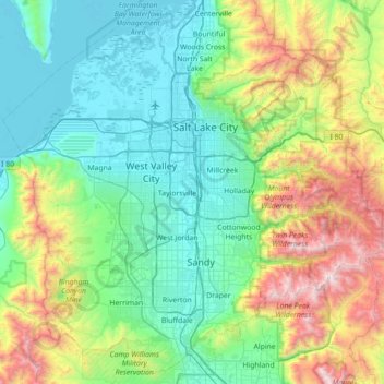
Name: Salt Lake County topographic map, elevation, terrain.
Location: Salt Lake County, Utah, United States (40.41417 -112.26022 40.92185 -111.55319)
Average elevation: 1,811 m
Minimum elevation: 1,278 m
Maximum elevation: 3,493 m
Make a donation
Gear up for your next adventure:
As an Amazon Associate, this site earns from qualifying purchases at no extra cost to you.
Other topographic maps
Click on a map to view its topography, its elevation and its terrain.
Uinta Mountains
The high Uintas were extensively glaciated during the last ice age, and most of the large stream valleys on both the north and south sides of the range held long valley glaciers. However, despite reaching to over 13,500 feet (4,110 m) in elevation, the climate today is sufficiently dry that no glaciers…
Average elevation: 2,363 m
Make a donation
Gear up for your next adventure:
As an Amazon Associate, this site earns from qualifying purchases at no extra cost to you.
Make a donation
Gear up for your next adventure:
As an Amazon Associate, this site earns from qualifying purchases at no extra cost to you.
Make a donation
Gear up for your next adventure:
As an Amazon Associate, this site earns from qualifying purchases at no extra cost to you.
Make a donation
Gear up for your next adventure:
As an Amazon Associate, this site earns from qualifying purchases at no extra cost to you.
Make a donation
Gear up for your next adventure:
As an Amazon Associate, this site earns from qualifying purchases at no extra cost to you.
Zion Canyon
United States > Utah > Washington County
Geologically Zion Canyon is part of the Navajo sandstone Colorado Plateau, which contained many joints and cracks when first uplifted, one of which was cut by the North Fork of the Virgin River to become Zion Canyon. The river was the largest force in cutting the canyon, mostly by flash floods, as the average…
Average elevation: 1,821 m
Antelope Island
United States > Utah > Davis County
The island is accessible via a 7-mile causeway from Syracuse in Davis County. Access from Interstate 15 is via exit 332, then west along Antelope Drive (SR-108). The island's shore (all but west side of the island) is mostly flat with beaches and plains to the base of the mountains on the island. These steep…
Average elevation: 1,306 m
Make a donation
Gear up for your next adventure:
As an Amazon Associate, this site earns from qualifying purchases at no extra cost to you.
Make a donation
Gear up for your next adventure:
As an Amazon Associate, this site earns from qualifying purchases at no extra cost to you.
Make a donation
Gear up for your next adventure:
As an Amazon Associate, this site earns from qualifying purchases at no extra cost to you.
Make a donation
Gear up for your next adventure:
As an Amazon Associate, this site earns from qualifying purchases at no extra cost to you.
Make a donation
Gear up for your next adventure:
As an Amazon Associate, this site earns from qualifying purchases at no extra cost to you.
Make a donation
Gear up for your next adventure:
As an Amazon Associate, this site earns from qualifying purchases at no extra cost to you.
Make a donation
Gear up for your next adventure:
As an Amazon Associate, this site earns from qualifying purchases at no extra cost to you.
Riverton Majestic Village
United States > Utah > Salt Lake County > Riverton
Average elevation: 1,369 m
Make a donation
Gear up for your next adventure:
As an Amazon Associate, this site earns from qualifying purchases at no extra cost to you.
Make a donation
Gear up for your next adventure:
As an Amazon Associate, this site earns from qualifying purchases at no extra cost to you.
Make a donation
Gear up for your next adventure:
As an Amazon Associate, this site earns from qualifying purchases at no extra cost to you.
Make a donation
Gear up for your next adventure:
As an Amazon Associate, this site earns from qualifying purchases at no extra cost to you.
Jordan River OHV/ Modelport State Park
United States > Utah > Salt Lake County > Salt Lake City
Average elevation: 1,286 m
Make a donation
Gear up for your next adventure:
As an Amazon Associate, this site earns from qualifying purchases at no extra cost to you.
Make a donation
Gear up for your next adventure:
As an Amazon Associate, this site earns from qualifying purchases at no extra cost to you.
Make a donation
Gear up for your next adventure:
As an Amazon Associate, this site earns from qualifying purchases at no extra cost to you.
Mount Ellen
United States > Utah > Garfield County
Mount Ellen is an ultra prominent peak, meaning that it has more than 1,500 metres (4,921 ft) of topographic prominence, standing out considerably from nearby mountains. It stands in the watershed of the Fremont River, which together with Muddy Creek forms the Dirty Devil River, which drains into the Colorado…
Average elevation: 3,149 m
Make a donation
Gear up for your next adventure:
As an Amazon Associate, this site earns from qualifying purchases at no extra cost to you.
Make a donation
Gear up for your next adventure:
As an Amazon Associate, this site earns from qualifying purchases at no extra cost to you.
Colorado Plateau
United States > Utah > San Juan County
Younger igneous rocks form spectacular topographic features. The Henry Mountains, La Sal Range, and Abajo Mountains, ranges that dominate many views in southeastern Utah, are formed about igneous rocks that were intruded in the interval from 20 to 31 million years: some igneous intrusions in these mountains…
Average elevation: 1,512 m
Make a donation
Gear up for your next adventure:
As an Amazon Associate, this site earns from qualifying purchases at no extra cost to you.
Make a donation
Gear up for your next adventure:
As an Amazon Associate, this site earns from qualifying purchases at no extra cost to you.
Make a donation
Gear up for your next adventure:
As an Amazon Associate, this site earns from qualifying purchases at no extra cost to you.
Make a donation
Gear up for your next adventure:
As an Amazon Associate, this site earns from qualifying purchases at no extra cost to you.