
Yerington topographic map
Interactive map
Click on the map to display elevation.
About this map
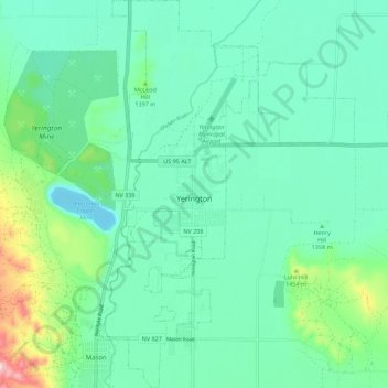
Name: Yerington topographic map, elevation, terrain.
Location: Yerington, Lyon County, Nevada, 89447, United States (38.94313 -119.18948 39.02976 -119.11681)
Average elevation: 1,358 m
Minimum elevation: 1,281 m
Maximum elevation: 1,640 m
During the summer, temperatures are generally hot to very hot in the afternoon, but the high altitude and low humidity means temperature drop to a comfortable level at night. On average, 8.0 afternoons each summer will exceed 100 °F or 37.8 °C and 73.2 afternoons reach 90 °F (32.2 °C). It is rare, though, that minima stay above 68 °F (20.0 °C), although thirteen mornings stayed this warm in 2015. The hottest minimum has been 78 °F (25.6 °C) on July 22, 2003, and the hottest temperature 107 °F (41.7 °C) on July 15, 2014. In the winter, afternoons are sunny and cool to cold with all but 4.6 topping freezing on average, although mornings typically range from freezing to frigid: 135.5 mornings fall below freezing in an average year and 0.6 fall to or below 0 °F (−17.8 °C). The coldest temperature on record is −26 °F (−32.2 °C) on January 21, 1937, and the coldest month January 1949 which averaged 12.4 °F (−10.9 °C) with a mean minimum of −4.6 °F (−20.3 °C). The coldest afternoon is 6 °F (−14.4 °C), which occurred on February 6, 1989, and December 22, 1990.