
Marie-Galante topographic map
Interactive map
Click on the map to display elevation.
Marie-Galante
The island of Marie-Galante is an elevated atoll resting on a rugged limestone substrate, located on the outer arc of the Caribbean plate. A fault called "la Barre" separates the northern quarter from the rest of the island. The north coast, facing Grande-Terre, is characterized by a high cliff, while the highest point, the Morne Constant (204 m altitude), is located to the east, in the territory of the municipality of Capesterre-de-Marie-Galante.
About this map
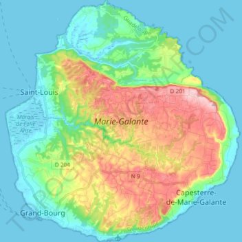
Name: Marie-Galante topographic map, elevation, terrain.
Location: Marie-Galante, Guadeloupe, France (15.86648 -61.33719 16.00741 -61.19493)
Average elevation: 52 m
Minimum elevation: -2 m
Maximum elevation: 194 m
Other topographic maps
Click on a map to view its topography, its elevation and its terrain.