
West Lima topographic map
Interactive map
Click on the map to display elevation.
About this map
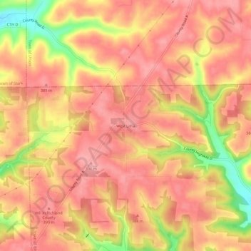
Name: West Lima topographic map, elevation, terrain.
Average elevation: 367 m
Minimum elevation: 290 m
Maximum elevation: 398 m
Other topographic maps
Click on a map to view its topography, its elevation and its terrain.
Richland Center
United States > Wisconsin > Richland County
Richland Center, Richland County, Wisconsin, 53581, United States
Average elevation: 264 m
Loyd
United States > Wisconsin > Richland County
Loyd, Town of Willow, Richland County, Wisconsin, United States
Average elevation: 291 m
Gotham
United States > Wisconsin > Richland County
Gotham, Town of Buena Vista, Richland County, Wisconsin, 53540, United States
Average elevation: 221 m